 INSPIRE-1
Contact for the resource
Bundesanstalt für Geowissenschaften und Rohstoffe
16 record(s)
Provided by
Type of resources
Available actions
Topics
Keywords
Contact for the resource
Service types
-
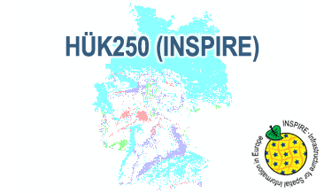
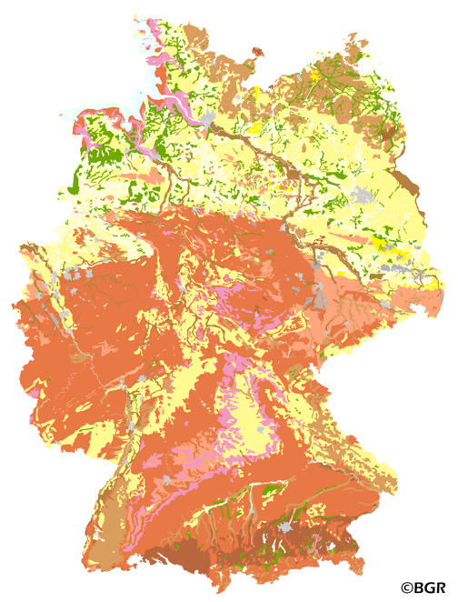
The HÜK250 (INSPIRE) describes the hydrogeological characteristics of the upper continuous aquifers in Germany at a scale of 1:250,000. According to the Data Specification on Geology (D2.8.II.4_v3.0) the map provides INSPIRE-compliant data. The hydrogeologic units are represented graphically – mostly according to the INSPIRE portrayal rules – by GE.Aquifer.MediaType, GE.Aquifer.HydrogeochemicalRockType, GE.Aquifer.permeabilityCoefficient (BGR colours), GE.Aquitard.approximatePermeabilityCoefficient (BGR colours), GE.Aquitard and GE.Aquiclude.ConstitutionOfAquiclude. The geologic units are represented graphically – according to the INSPIRE portrayal rules – by GE.GeologicUnit.AgeOfRocks and GE.GeologicUnit.Lithology. The HÜK250 is a joint project of the SGD under the leadership of the BGR.
-
The HÜK250 (INSPIRE) describes the hydrogeological characteristics of the upper continuous aquifers in Germany at a scale of 1:250,000. According to the Data Specification on Geology (D2.8.II.4_v3.0) the content of the map is stored in a INSPIRE-compliant GML file: HUEK250.gml. The GML file together with a Readme.txt file is provided in ZIP format. The Readme.txt file (German/English) contains detailed information on the GML file content. Data transformation was proceeded by using the INSPIRE Solution Pack for FME according to the INSPIRE requirements.
-
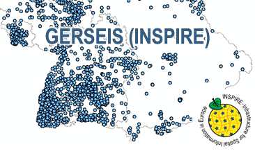
The German Earthquake Catalogue is based on a database providing information on the seismicity in Germany an adjacent areas. It contains locations of seismic events since year 800 where their epicentre determinations are based on historical sources as well as on measurements at seismometer stations since the start of instrumental seismological recording in the 20th century. Today, digital data acquisition at seismometer stations of the German regional seismic network (GRSN), the seismic GERES array, and the Gräfenberg array (GRF) takes place. All events with a local magnitude ML 2.0 and higher are listed. The GML file together with a Readme.txt file are provided in ZIP format (GERSEIS-INSPIRE.zip). The Readme.text file (German/English) contains detailed information on the GML file content. Data transformation was proceeded by using the INSPIRE Solution Pack for FME according to the INSPIRE requirements. Due to the continuous processing of the seismic events, the INSPIRE dataset is updated annually.
-
The Map of Mineral Resources of Germany 1: 1,000,000 (BSK1000) provides the basic information on the spatial distribution of energy resources and mineral raw materials (‘stones and earth’, industrial minerals and ores) in Germany. The mineral resources are summarized in commodity groups, represented as different colored units. The map is published by the Federal Institute for Geosciences and Natural Resources in cooperation with the National Geological Surveys.
-
Der WMS GERSEIS (INSPIRE) zeigt die seismologischen Ereignisse, die im Deutschen Erdbebenkatalog der BGR fortlaufend gespeichert werden. Dieser Katalog liefert Informationen zum seismischen Geschehen in Deutschland und benachbarten Gebieten. Er beinhaltet die Orte, an denen seit dem Jahr 800 seismische Ereignisse stattfanden. Grundlage für die Epizentrumsbestimmung sind historische Quellen sowie seit Beginn der instrumentellen Erdbebenaufzeichnung im 20. Jahrhundert Messungen mit Seismometerstationen. Die digitale Datenerfassung findet an den Seismometerstationen des Deutschen Regionalnetzes (GRSN) sowie den Messanlagen des GERES-Arrays und des Gräfenberg-Arrays (GRF) statt. Es werden alle Ereignisse mit einer lokalen Magnitude ML 2,0 oder aufgelistet. Aufgrund der kontinuierlichen Erfassung der seismischen Ereignisse wird der INSPIRE-Datensatz in jährlichem Abstand aktualisiert. Der WMS GERSEIS (INSPIRE) beinhaltet ein Layer mit den seismologischen Ereignissen (NZ.ObservedEvent), die gemäß der INSPIRE-Darstellungsregeln abgebildet sind. Mit Hilfe der getFeatureInfo-Anfrage erhält der User die Inhalte der INSPIRE-Attribute unitsOfMeasure, qualitativeValue, quantitativeValue, validFrom, intensityScale (Kurzname der Intensitätsskala aus dem Attribut citation). The WMS GERSEIS (INSPIRE) represents the seismological events of the German Earthquake Catalogue which is based on a database providing information on the seismicity in Germany and adjacent areas. It contains locations of seismic events since year 800 where their epicentre determinations are based on historical sources as well as on measurements at seismometer stations since the start of instrumental seismological recording in the 20th century. Today, digital data acquisition at seismometer stations of the German regional seismic network (GRSN), the seismic GERES array, and the Gräfenberg array (GRF) takes place. All events with a local magnitude ML 2.0 and higher are listed. Due to the continuous processing of the seismic events, the INSPIRE dataset is updated annually. The WMS GERSEIS (INSPIRE) contains a layer of the seismological events (NZ.ObservedEvent) displayed correspondingly to the INSPIRE portrayal rules. Via the getFeatureInfo request the user obtains the content of the INSPIRE attributes unitsOfMeasure, qualitativeValue, quantitativeValue, validFrom and intensityScale (short name of citation of the intensity scale).
-
Web Map Service (WMS) of the BUEK1000. The first country wide soil map at a scale of 1:1,000,000 (BUEK1000) has been compiled on the basis of published soil maps of the former German Democratic Republic and the pre 1990 federal states of Germany. To do this, it was necessary to match the soil systems used in East and West Germany and to develop standardized descriptions of soil units. A relatively homogeneous map has resulted, which permits uniform assessment of the soils throughout Germany. The map shows 71 soil mapping units, described in the legend on the basis of the German and FAO soil systems. Each soil unit has been assigned a characteristic soil profile (Leitprofil) as an aid to map interpretation. For the first time the subdivision of the country into 12 soil regions has been represented on the map. This subdivision was coordinated with the state Geological Surveys. These soil regions will represent the highest hierarchic level of nation wide soil maps in future. The colours of soil units correspond to the standards of the 'Bodenkundliche Kartieranleitung' (KA 3; Guidelines for Soil Mapping). The various hues characterize differences in relief or soil humidity. The BUEK1000 was produced digitally. It is an important part of the spatial database integrated in the Soil Information System currently being established at the Federal Institute for Geosciences and Natural Resources (FISBo BGR). It can be used together with the characteristic soil profiles to derive thematic maps related to nation wide soil protection. The scale of the BUEK1000 makes it especially suitable for small scale evaluations at federal or EU level.
-
The Web Map Service (WMS) shows the distribution of typical soil types (soil texture) in the topsoils of Germany. Typical is used in the term of areally dominating. The map visualizes the results of the project that are documented in a BGR report (Bodenarten der Böden Deutschlands; BGR Archiv, Nr. 0127305). The soil texture data from the analysis of the particle size distribution for 16,132 sites in Germany were classified after the legend units of land use-stratified soil map of Germany 1: 1,000,000 (BÜK1000N V2.3) and mean soil texture were calculated. Considering the large heterogeneity in the data and the resulting uncertaintly in the precision for a site the depiction of the obtained soil texture is presented at the level of the soil types group, according to the German soil classification system (KA5).
-
Web Map Service (WMS) of the map Organic Matter Content of Top-Soils in Germany. The map Organic Matter Content of Top-Soils in Germany 1:1,000,000 highlights the results of a Germany-wide compilation of typical soil organic matter contents in top-soils differentiated according to 15 groups of soil parent material, four climatic areas and the main land use. The evaluation is based on more than 9000 soil data profiles with information about Soil Organic Matter (SOM) from a period of about 20 years. The report 'The Organic Matter Content of Top-Soils in Germany', BGR Archiv, No. 0127036 (in German) documents the methodology. The classes of the map legend are based on the classes given in the German Soil Mapping Guideline, 5th Edition (KA5). The version 2.0 of the map is based on the Digital Topographic Map 1:1,000,000 (DTK1000-V) of the Federal Agency for Cartography and Geodesy, which was altered in parts by BGR.
-
Web Map Service (WMS) of the map Groups of soil parent material in Germany 1:5,000,000. The presented map at scale 1:5,000,000 shows the distribution of 15 soil parent material groups in Germany with polygons of at least 64 square kilometers. Parent material is the rock, from which soil is formed. It was derived from the landuse use stratified soil map of Germany at scale 1:1,000,000. The version 3.0 of the map is based on the Digital Landscape Model 1:1,000,000 (DLM1000) of the Federal Agency for Cartography and Geodesy.
-
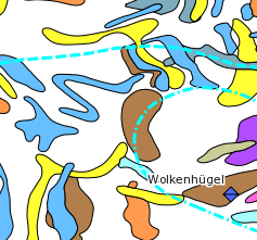
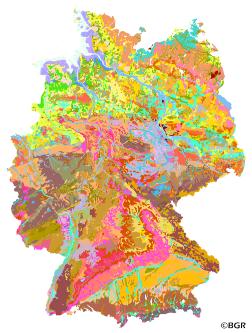
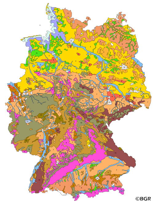
The map series General Geological Map of the Federal Republic of Germany 1:200,000 (GÜK200) is the result of cooperation between the State Geological Surveys of the Federal Republic of Germany (SGD), the Geological Surveys of neighbouring countries and the Federal Institute for Geosciences and Natural Resources (BGR). The GÜK200 displays the surface geology of Germany and adjacent areas of neighbouring countries on 55 map sheets. The map sheets show the regional dissemination of more than 3800 geological units. The geological units contain information on stratigraphy (age), genesis and petrography (composition) of the rocks. Each printed/scanned map sheet contains one or several geological cross-sections which give an insight into the subsurface. The digital data of the map series are stored separately for each map sheet. According to this geological units/polygons, their boundaries, tectonic linear elements and, if present, ice sheet boundaries are saved as a discrete layer in a shapefile for the single map sheets. The attributes of the geological units contain information – like in the printed map sheets – on stratigraphy, genesis and petrography of the rocks.